

A Land Parcel and Stakeholder Management Platform for a Land Services Software Company

Scroll Down

Jump to Section
3 Min Read time
Quick Snapshot
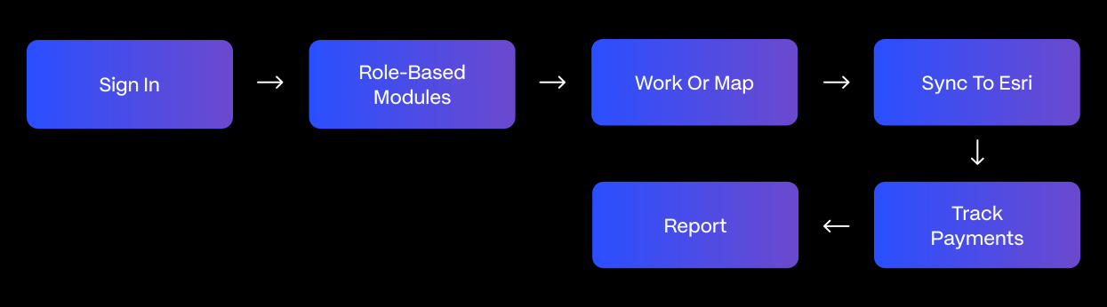
Technostacks built land management software for a Calgary-based land, stakeholder, and project management company. The platform unifies parcel mapping, stakeholder engagement, and project administration in one system, syncing parcel data directly to Esri for real-time 2D/3D visualization. Every landowner interaction, payment, and time entry logs to the right parcel and project, and an animated Engagement Map with a time slider shows stakeholder sentiment across a project’s full lifecycle. Shaped by the real-world land acquisition workflow of one of the client’s own customers, a land services company handling landowner negotiations for energy and infrastructure projects, the platform replaced spreadsheets and paper notes with a searchable, auditable system of record.
Brief
The client’s land and project management work, driven by the operational needs of one of its own customers- a land services company handling land acquisition and landowner negotiations for energy and infrastructure projects ran on paperwork and manual notes. As the portfolio grew, the client brought the project to Technostacks to build a dedicated platform from scratch.
Technostacks designed and built the platform from the ground up, shaped directly by that customer’s operational requirements. It brings parcel mapping, stakeholder engagement, and project operations into one system, syncs parcel data directly to Esri, logs every interaction against the right parcel and project, and visualizes sentiment through an animated Engagement Map.
Challenges
No Digital System in Place
Parcels, stakeholders, and payments were tracked manually across spreadsheets and paper notes.
No Centralized Parcel View
There was no single view of parcel status, ownership or location.
No Esri Sync Pipeline
Nothing kept parcel data accurately synced with Esri for geospatial mapping.
Interactions Not Linked to Parcels
Stakeholder interactions weren’t tied to specific parcels or projects, making history hard to trace.
No Visibility Into Sentiment
There was no way to see stakeholder sentiment or engagement trends over a project’s timeline.
No Multi-Client Data Structure
Nothing isolated data across multiple companies and projects as the client base grew.
Solution We Provide
Technostacks built a unified land, stakeholder, and project management platform, shaped directly by field operations from one of the client’s own customers.
Centralized Stakeholder Profiles
Every landowner interaction logs against the right parcel and project, replacing scattered notes with a full, searchable history.
Animated Engagement Map
A time-slider visualizes stakeholder sentiment and activity trends across a project’s full lifecycle, giving leadership a spatial view of engagement.
Real-Time 2D/3D Parcel Mapping
Parcels sync automatically to Esri, replacing manual spreadsheet tracking with live geospatial visualization of ownership, status, and adjacent parcels.
Multi-Tenant Company & Project Structure
Role-based access isolates each customer’s data, letting the client run multiple organizations side by side on one platform.
Automated Payments & Time Tracking
Payment scheduling, reminders, and time and expense tracking tie directly to field activity, keeping finance connected to relationship data.
Real-Time Filterable Dashboards
Reporting across companies, projects, and team members gives leadership live analytics without manual compilation.
How It Works
Technologies Used
Frontend: React, TypeScript, Material UI
Backend: Node.js, Express
Database: MongoDB
GIS: ArcGIS Esri
Deployment: AWS Amplify
Email: SendGrid
Impact
The platform gave the client a live system of record in place of spreadsheets and paper notes:
Conclusion
The platform gave the client a single source of truth for parcels, stakeholders, and project operations, replacing spreadsheets and paper notes with a live system tracking parcels, acres, stakeholders, and interactions. Built around a real customer’s land acquisition workflow, it turns scattered engagement history into searchable, auditable records and gives field teams spatial context and ownership detail without leaving the app.
With a multi-tenant structure, automated payments and reminders, and real-time dashboards, the client is now equipped to run multiple customer organizations, starting with the one that shaped this build, side by side on one platform, with the data isolation, audit trail, and reporting it needs to onboard new customers and scale without rebuilding the system each time.
Building a Platform for Land, Stakeholder or Project Management?
Whether it’s parcel mapping, stakeholder engagement, or multi-tenant project operations, we can build a platform that keeps every relationship and record tied to the land it concerns.
Our Solutions in Action
-
Software & Platforms • Cloud & DevOps • Digital Products • Internet of Things (IoT) • Product Engineering: A Map-First Geospatial Platform for Drone, Seedcane and Field Operations

A Map-First Geospatial Platform for Drone, Seedcane and Field Operations
Sense SaaS brings farm and site operations onto one map. Landowners order drone and lab services against mapped fields, growers manage certification and yield programmes, and field teams cap…
-
Real Estate • Cloud & DevOps • Data & AI • Digital Products • Product Engineering: Automated Utility Bill Data Extraction for Property Portfolios
Automated Utility Bill Data Extraction for Property Portfolios
BillSlayer reads electricity, water, refuse, and municipal rates bills on its own and turns them into live cost dashboards. Owners forward a bill by email, WhatsApp, or web upload, and the n…

-
Real Estate • Data & AI • Digital Products • Product Engineering: From Fragmented Systems to One Dashboard: A PropTech Platform for Modus10
From Fragmented Systems to One Dashboard: A PropTech Platform for Modus10
Modus10 (a South Africa-based property management firm) now runs leasing, utilities, access control, and tenant services from a single dashboard, replacing the paperwork and disconnected sys…

-
Industrial • Data & AI • ERP • Generative AI: From Stuck to Resolved: An AI Agent for ERP Exception Resolution
From Stuck to Resolved: An AI Agent for ERP Exception Resolution
Turning ERP exceptions into explanations and recommended fixes.

-
Real Estate • ERP: From Spreadsheets to a Single Source of Truth: Custom Real Estate CRM and HRMS Platform – Part 1
From Spreadsheets to a Single Source of Truth: Custom Real Estate CRM and HRMS Platform – Part 1
Imagine a broker checking unit availability in one spreadsheet, calculating brokerage in a second, hunting for the signed agreement in a shared drive, and messaging HR separately to log a re…

-
Industrial • Data & AI • ERP • Generative AI: AI-Powered ERP Automation for Predictive Supply Chain & Inventory
AI-Powered ERP Automation for Predictive Supply Chain & Inventory
From reactive ERP reports to predicted, human-approved reorders.

-
Industrial • Data & AI • ERP • Generative AI: From Emails to ERP Transactions: AI-Powered Order Processing for Unstructured Requests
From Emails to ERP Transactions: AI-Powered Order Processing for Unstructured Requests
A one-line email asking to ship 500 units becomes a validated ERP sales order, read, matched to the right customer and material, and entered without anyone retyping a thing.
-
Industrial • Data & AI • ERP • Generative AI: AI-Powered Procurement Automation for Manufacturing
AI-Powered Procurement Automation for Manufacturing
How AI Eliminated Manual Procurement Across Manufacturing Ops
-
Real Estate • ERP: One Platform, Every Stage: A Connected ERP for the Complete Property Development Lifecycle
One Platform, Every Stage: A Connected ERP for the Complete Property Development Lifecycle
One ERP for Land, Construction, Sales, Finance & Delivery


Lets Talk
Have a challenge?Let us know.