

A Map-First Geospatial Platform for Drone, Seedcane and Field Operations

Scroll Down

Jump to Section
3 Min Read time
Quick Snapshot
Technostacks delivered geospatial software development for Sense SaaS, a multi-tenant platform where every farm, field, block, and site is a real object on a map, and every product works against those objects. On that core sits a services marketplace for ordering drone flights and lab analysis, a seedcane register for certifying sugarcane planting material, grower info packs for yield estimates, and an offline field app for GPS capture and sampling. It replaced phone bookings, WhatsApp threads, and paper forms with one system of record. A Kafka event backbone processes imagery and notifications in the background, and a database-driven configuration layer lets the client add providers and rules without a software release.
Brief
Agricultural operations data lived in files and on paper that nobody could query. Providers took orders by phone and delivered results as files the customer often couldn’t open. Seed cane certification and volume commitments ran on paper and email, growers received estimates as static documents, and field teams recorded boundaries by hand, each workflow with its own tools and no shared view of the land it was about.
Technostacks built Sense SaaS as one geospatial platform: a Vue 3 web app, an installable offline field app, a Django REST API, PostgreSQL/PostGIS with GeoServer for maps, and a Kafka pipeline for background processing. Drone imagery, lab orders, inspections, estimates, and field samples now attach to the same mapped assets and surface in the same dashboards.
Challenges
Every Workflow Was a Separate Island
Service orders, inspections, estimates, and field samples lived in different tools, with no shared record of the field they described.
Critical Data Locked in Files
Drone rasters, lab orders, and inspection sheets could be stored but not queried, compared, or mapped.
Paper-Based Industry Workflows
Seed cane moves through several stages, each needing sign-off and an audit trail that paper and email could not provide.
Field Teams Work Without Signal
Boundary capture and sampling happen on farms with poor connectivity, so a web-only tool fails where the data is collected.
Every Partner Works Differently
Service packages and business rules differ per partner, so hard-coding them would mean a release for every change.
Large Files Blocked Users
Gigabyte survey rasters would stall the interface if processed while the user waits.
Solution We Provide
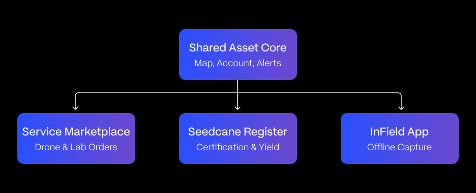
Technostacks built Sense SaaS as a map-first platform where every product attaches to the same mapped assets instead of building its own data model.
Map-First Asset Core
Farms, fields, and sites are drawn on an OpenLayers map, stored in PostGIS and served through GeoServer, nested into hierarchies that every module attaches to.
Services Marketplace and Ordering
Providers publish packages such as drone flights and lab analysis with their own order forms. Customers order against mapped assets, and providers move orders through a lifecycle with both sides notified.
Drone Data Pipeline
Uploaded imagery is virus-scanned, then Kafka runs parallel jobs to extract location, build previews, and convert rasters for streaming results appear as map layers over the customer’s fields.
Seedcane Register
Tracks planting material through fallow, planting, and ratoon stages on certified streams, with every inspection and change written to an audit log.
Grower Info Packs
Secure mobile packs give growers yield estimates and ripener orders over satellite layers, while managers review activity across the grower base.
Offline Field App
An installable app lets field teams capture boundaries by GPS and log samples offline, work syncs once the device reconnects.
Shared Configuration Engine
A rules engine, form builder, and dashboards are shared by every product, so most changes ship as configuration, not code.
How It Works
Three flows run on the same core, each ending with data landing on the map:
Technologies Used
Frontend: Vue 3, TypeScript, Tailwind CSS, Kendo UI for Vue, offline PWA
Mapping & Geospatial: OpenLayers, GeoServer, PostGIS, GDAL, Cloud Optimized GeoTIFF, Sentinel Hub
Backend: Python 3.12, Django 5, Django REST Framework, Celery, Redis
Event Pipeline: Apache Kafka
Imagery & Files: Pillow, OpenCV, ClamAV virus scanning
Database: PostgreSQL 16, PostGIS 3
Integrations: SendGrid, Twilio, Zoho Subscriptions, Paystack, SAML SSO
Security & DevOps: JWT, TOTP MFA, FIDO2/WebAuthn, Docker, GitLab CI/CD, Sentry
Export Formats: CSV, Excel, PDF, GeoJSON, Shapefile, GeoTIFF
Impact
Sense SaaS replaced phone bookings, emailed files and paper forms with one geospatial platform where every piece of operational data belongs to a place on the map:
Conclusion
Technostacks turned agricultural operations that lived in files, phone calls, and paper forms into one geospatial platform where every workflow attaches to a place on the map. Landowners order drone and lab services in one flow, growers manage certification with a full audit trail, and field teams capture data offline that lands on the web platform; all sharing one core instead of running as separate tools.
The client is now equipped to launch new products on the same foundation: new providers, packages, partner brands, and rules are configuration, not code. The same core of assets, orders, background processing, and offline capture fits any business that manages work and data against land, from other crops to new regions.
Building a Platform on Maps, Not Files?
Whether it’s service ordering, field data capture, or multi-product operations tied to physical locations, Technostacks can build a geospatial platform that keeps every workflow attached to the place it happens.
Our Solutions in Action
-
Software & Platforms • Cloud & DevOps • Digital Products • Product Engineering: A Land Parcel and Stakeholder Management Platform for a Land Services Software Company

A Land Parcel and Stakeholder Management Platform for a Land Services Software Company
The platform brings parcel mapping, stakeholder engagement, and project operations onto one system for a Calgary-based land, stakeholder, and project management software company, replacing s…
-
Real Estate • Cloud & DevOps • Data & AI • Digital Products • Product Engineering: Automated Utility Bill Data Extraction for Property Portfolios
Automated Utility Bill Data Extraction for Property Portfolios
BillSlayer reads electricity, water, refuse, and municipal rates bills on its own and turns them into live cost dashboards. Owners forward a bill by email, WhatsApp, or web upload, and the n…

-
Real Estate • Data & AI • Digital Products • Product Engineering: From Fragmented Systems to One Dashboard: A PropTech Platform for Modus10
From Fragmented Systems to One Dashboard: A PropTech Platform for Modus10
Modus10 (a South Africa-based property management firm) now runs leasing, utilities, access control, and tenant services from a single dashboard, replacing the paperwork and disconnected sys…

-
Industrial • Data & AI • ERP • Generative AI: From Stuck to Resolved: An AI Agent for ERP Exception Resolution
From Stuck to Resolved: An AI Agent for ERP Exception Resolution
Turning ERP exceptions into explanations and recommended fixes.

-
Real Estate • ERP: From Spreadsheets to a Single Source of Truth: Custom Real Estate CRM and HRMS Platform – Part 1
From Spreadsheets to a Single Source of Truth: Custom Real Estate CRM and HRMS Platform – Part 1
Imagine a broker checking unit availability in one spreadsheet, calculating brokerage in a second, hunting for the signed agreement in a shared drive, and messaging HR separately to log a re…

-
Industrial • Data & AI • ERP • Generative AI: AI-Powered ERP Automation for Predictive Supply Chain & Inventory
AI-Powered ERP Automation for Predictive Supply Chain & Inventory
From reactive ERP reports to predicted, human-approved reorders.

-
Industrial • Data & AI • ERP • Generative AI: From Emails to ERP Transactions: AI-Powered Order Processing for Unstructured Requests
From Emails to ERP Transactions: AI-Powered Order Processing for Unstructured Requests
A one-line email asking to ship 500 units becomes a validated ERP sales order, read, matched to the right customer and material, and entered without anyone retyping a thing.
-
Industrial • Data & AI • ERP • Generative AI: AI-Powered Procurement Automation for Manufacturing
AI-Powered Procurement Automation for Manufacturing
How AI Eliminated Manual Procurement Across Manufacturing Ops
-
Real Estate • ERP: One Platform, Every Stage: A Connected ERP for the Complete Property Development Lifecycle
One Platform, Every Stage: A Connected ERP for the Complete Property Development Lifecycle
One ERP for Land, Construction, Sales, Finance & Delivery


Lets Talk
Have a challenge?Let us know.